
Samantha Hansen says she enjoys problem solving. Good thing, ‘cause she’s dealing with a doozy.
This University of Alabama geologist wants to better understand how a mostly ice-buried mountain range formed 55 million years ago near the South Pole. Sound daunting? Stay tuned.
She’s using earthquakes occurring today thousands of miles from those mountains to help unravel the puzzle. Thankfully, technology … and a warm pair of boots … are on her side.
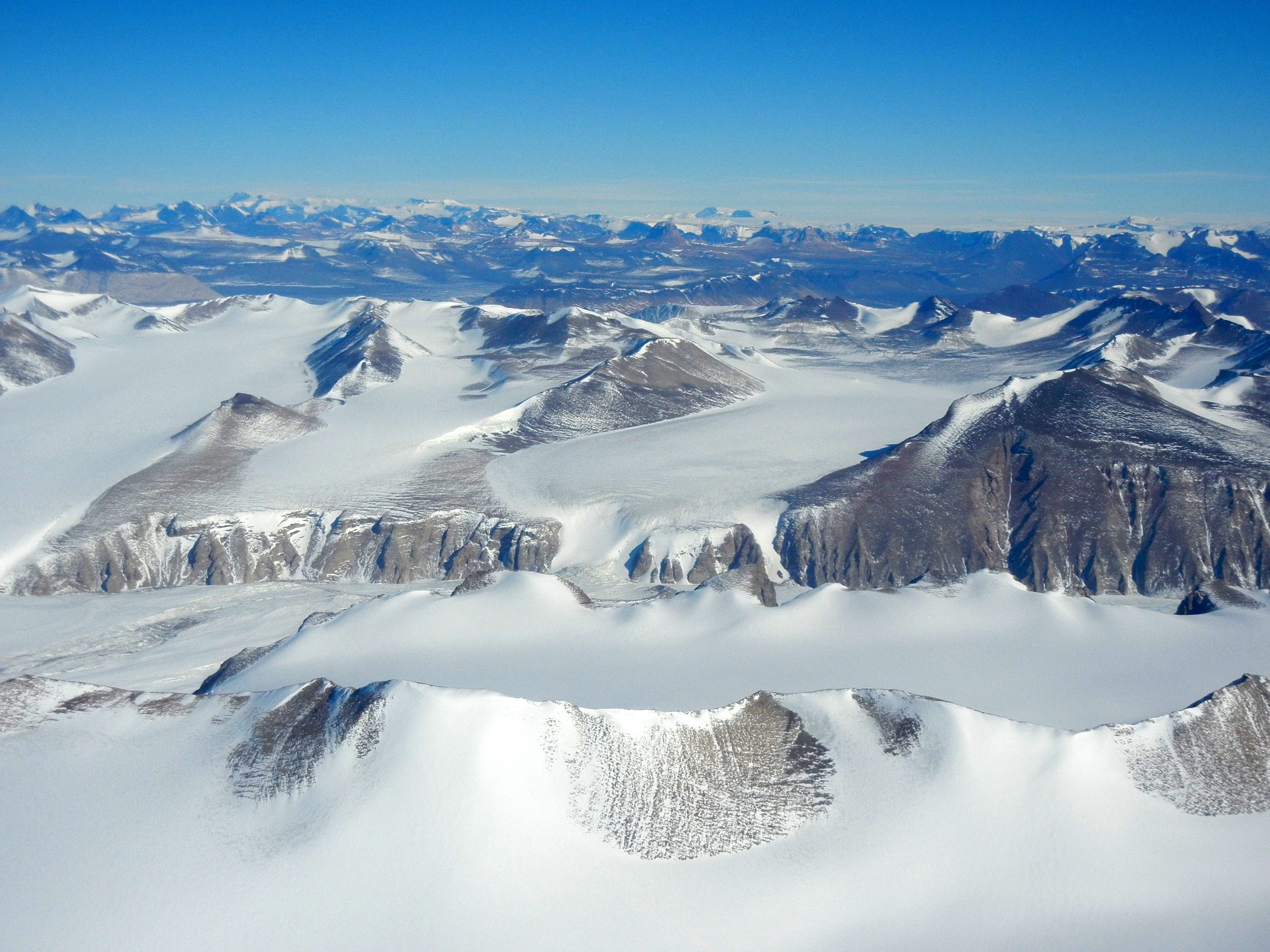
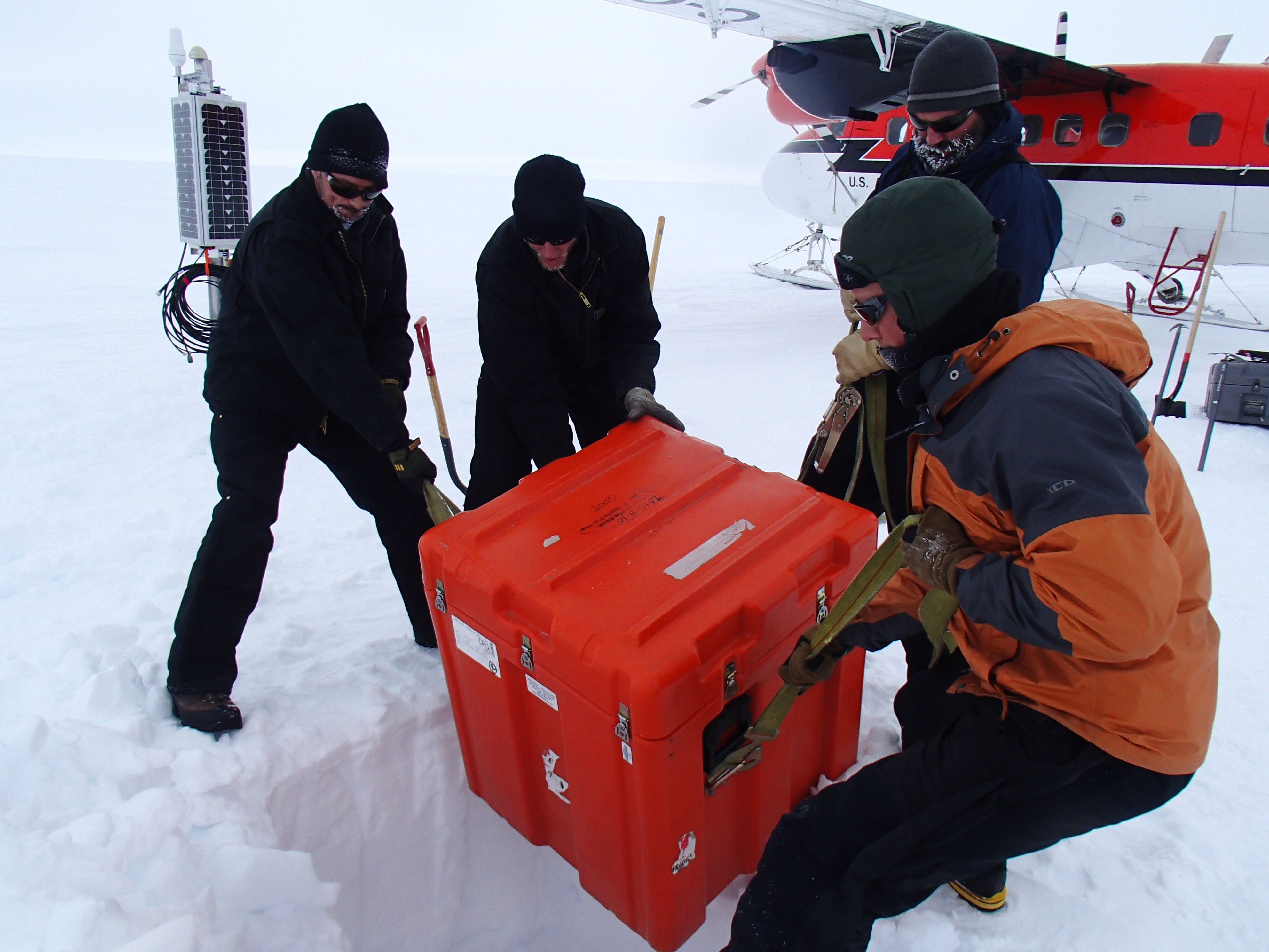
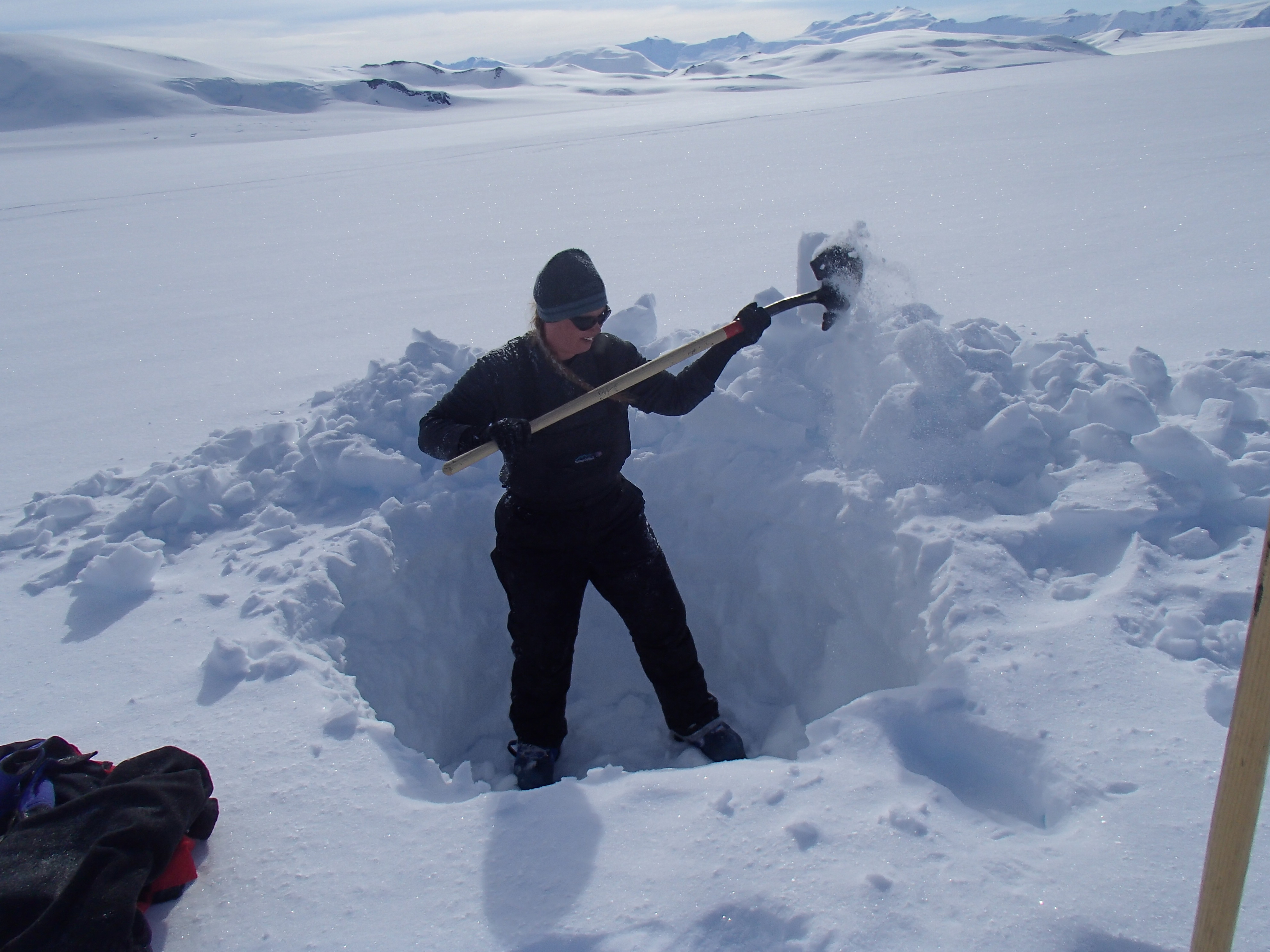
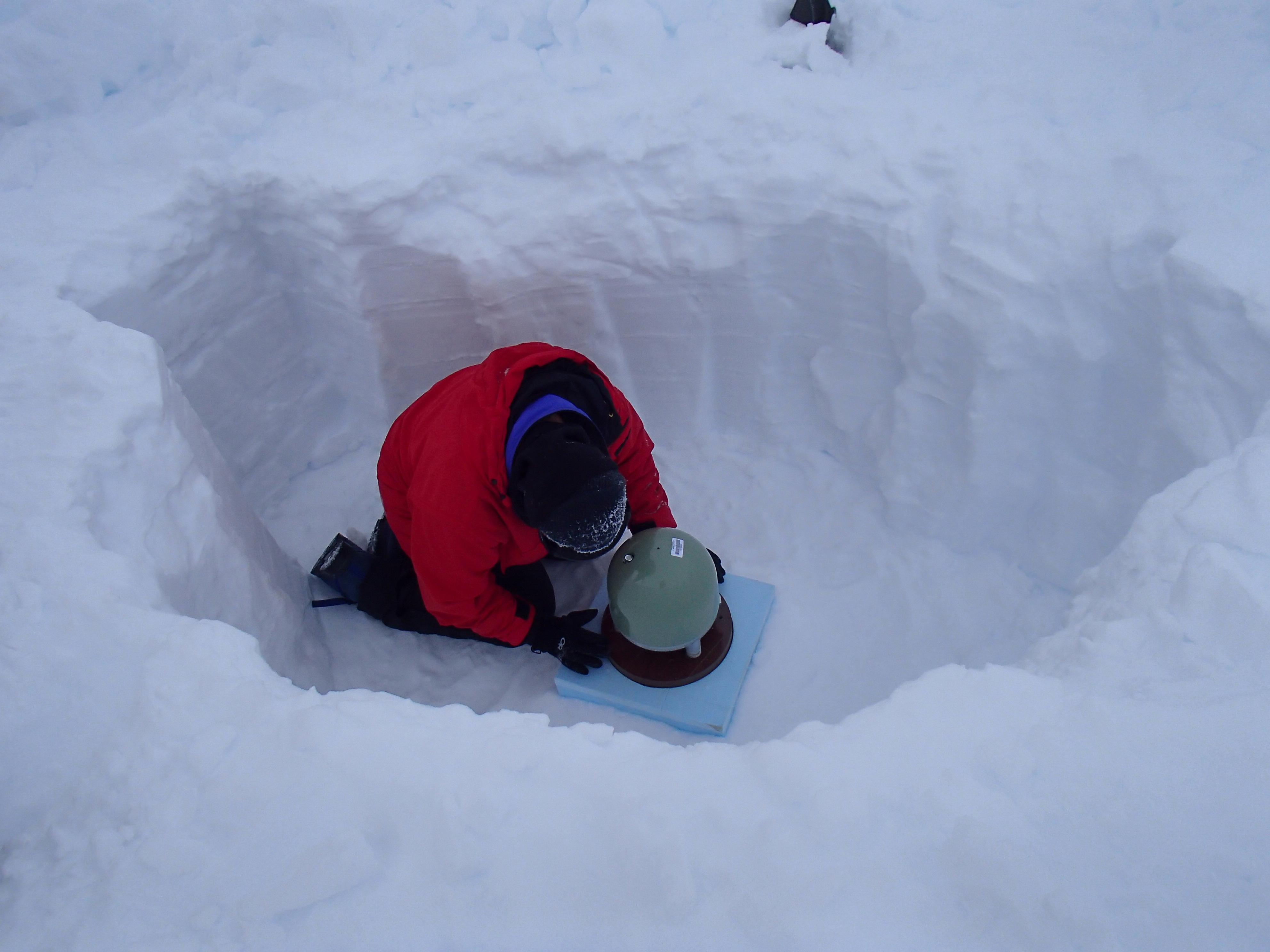
Hansen and two UA graduate students, Jordan Graw, of Germantown, Tenn., and Lindsey Kenyon, of Deephaven, Minn., spent Thanksgiving 2012 (and a few weeks on either side of it) in Antarctica installing 15 seismic stations across an approximately 61,000-square-mile, snow-covered area along the Transantarctic Mountains.
More than 99 percent of Antarctica is covered by ice sheets. This includes most of even the very mountain peaks in which Hansen is interested.
“Surface observation is a little tough to pull off when everything is buried,” Hansen says. “The only way we can figure out what is happening beneath the ice sheets and what is going on with these structures is to use geophysical, ‘remote sensing’ type approaches.”
Over a three-year period, the stations will record data from most earthquakes having a magnitude of 5.5 or higher regardless of where in the world they occur. When earthquakes occur, a tremendous amount of energy is distributed in all directions throughout the earth’s interior.
“We use that energy to image the inside of the earth,” Hansen says.
Through this imaging, scientists can come closer to understanding some of the mountain range’s characteristics deep beneath the surface and can develop more accurate theories about the manner in which it formed.
To better understand how this works, Hansen suggests thinking of a medical CAT scan. By distributing energy through a patient’s body and recording it with instrumentation as it exits the body, a CAT scan images the inside of the patient, she says.
“A lot of what we are doing in seismology is somewhat analogous to that,” Hansen says. “You are using energy from an earthquake — a given source of energy. It moves through the interior of the earth just like the energy in a CAT scan does in your body, and it gets recorded by our stations.”
It’s not, of course, a perfect analogy.
“Unlike a CAT scan where they have perfect control over where all the sources and all the receivers are, so you can get a really nice image of your internal structure, we are a little bit limited because earthquakes only happen in certain places around the world,” Hansen says. “And, you can only put stations in so many places. You have an imperfect image, but it’s getting better.”
As the quakes’ energy signals arrive at the stations installed by Hansen and her colleagues, recordings of those signals’ velocity, amplitude and other attributes provide the scientists with data that can be plugged into computer models that can, in turn, create imagery of what lies below the surface.
“You can kind of back infer the characteristics inside the earth that led to that signal.”
Hansen calls this mountain range “peculiar,” and says one of the reasons she finds it intriguing is because it did not form in a similar fashion to most other mountain ranges.
Many others were formed by “taking two continents and running them into each other,“ Hansen says. The Himalayas are a classic example, as they formed, Hansen says, when India was driven headlong into Asia. Such mountains are referred to as compressional.
“The Transantarctics don’t have any evidence of compressional origin. If you look at the structure and rocks, they don’t look like they formed in your traditional mountain-building approach. So, the big question is, how did they form and, ultimately, how does this relate to the tectonic history of the continent?
“The Transantarctics are the largest non-compressional mountain range in the world.”
Their continent, Antarctica, is also the coldest on the planet.
Hansen will take her fourth trip to the ultimate land down under when she visits Antarctica again in November along with her two students. They will retrieve data from the stations – unlike many locations there is neither sufficient power supply nor bandwidth in Antarctica to transmit the data to Hansen, so she must physically retrieve it. The group will also check to see if service or repairs are needed to the equipment now buried underneath several feet of snow.
“It’s completely unlike any place I’ve ever been,” Hansen says. There is so much … nothing. It’s just absolutely remote. Sometimes, I’ll admit, that can be kind of overwhelming or lonely. But, it’s also very peaceful.
“It’s interesting being some place where there are no trees and no animals, no people and no houses. Some of the sites we’ve visited … no other human had ever been to before. That’s pretty cool, especially in this day and age, going someplace that you are the first human beings to be there.”
Taken another way, it’s more than just pretty cool. She recalls one day when the temperature hovered near minus 80. Other days, when the winds are not howling and the sun is shining, it’s practically balmy. Ok, well, not quite balmy.
“On a nice day, it will get up in the thirties. With the sun coming down, it’s actually quite warm.”
Government-issued polar gear keep the scientists comfortable … and alive.
“It’s amazingly awesome gear,” Hansen says. “I don’t know anywhere else in the world you would wear it because you would die from heat exhaustion.”
During their visits, the researchers live primarily at McMurdo Station, an American-operated research station in Antarctica, and spend some nights at Mario Zuchelli Station, a unit operated by the Italian government. From those base sites, the UA researchers are flown in either helicopters or Twin Otter aircraft to the seismic-station locations. Some of the research sites are only 20 minutes from the base stations while others require a 2.5-hour flight.
The daughter of an engineer and a computer programmer, Hansen says she dug into her love of geology somewhat randomly.
“I was always a science-math geeky kid,” she says while sitting in her campus office, looking very non-geeky, with a small nose-ring in place. “I come from a math-science geeky family so they were very supportive of my decision to go into something along these lines.”
As an undergraduate at the University of Wisconsin, Hansen triple majored in engineering, geophysics and geology, discovering along the way that she liked geophysics and geology best, so she focused on these for her advanced degrees from Wisconsin and the University of California, Santa Cruz and in her post-doctoral work at Penn State, the place where she first became involved in Antarctic research.
Today, she indicates her satisfaction with her career choice, expressing excitement in working with students and the challenges involved in her work.
“I like to travel and this job allows me to do quite a bit of that. I have been to every continent on the planet minus one (Asia). Between the field work I do and conferences, it affords me some cool opportunities to go to some really interesting places.
“The research aspect I find interesting because you are looking at things that are completely different, completely unanswered questions that you get to figure out. That discovery aspect of it is really appealing to me. I like problem solving.
“Antarctica, in particular, is a neat place to work because so little has been done there before that everything you do is kind of sexy and exciting. It is all brand new discovery, being on the forefront of polar science.”
Dr. Hansen is an assistant professor of geological sciences in UA’s College of Arts and Sciences. This aspect of her research is funded through a five-year $715,000 CAREER grant from the National Science Foundation.
Contact
Linda Hill, UA Public Relations, 205/348-8325, lhill@ur.ua.edu