by Chris Bryant
A University of Alabama geographer is monitoring the Gulf of Mexico’s water quality from a few hundred miles inland. In fact, with some assistance from a satellite orbiting some 438 miles above the Pensacola, Fla. area, he can measure the water’s ever changing quality from his office on the UA campus.
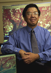
Dr. Luoheng Han, associate professor of geography in UA’s College of Arts and Sciences, is part of a team researching environmental conditions in the Gulf of Mexico, particularly those surrounding Pensacola and Mobile bays. Han is the team’s sole researcher focusing on “remote sensing” of water quality, a technique by which environmental conditions of an area are derived from satellite imagery.
“Remote sensing is clearly the future of data collection,” said Han.
A sensor aboard an orbiting satellite measures the brightness of radiation reflected from specific items, such as chlorophyll, which are in bodies of water. As the spectral signatures — the reflected energy levels at specific wavelengths — of some of these items are unique, the quality and quantity of these elements can be determined by the remote sensed imagery.
Han logs onto a U.S. Geological Survey web site on the Internet to access the satellite images. Various shades of blues, greens, and browns appear on the map displayed upon Han’s computer screen. “The images of the Pensacola Bay, for example, contain seven different spectral bands,” Han said. “It’s not like a conventional photograph.”
Using mathematical and neural network algorithms being developed by Han, numerical values are assigned to the various shades. These values represent, for examples, how much chlorophyll is in the water or the degree of sediment present. An overabundance of chlorophyll may signal severe oxygen depletion, known as hypoxia. Fish avoid these oxygen depleted waters, and lobsters, shrimp and crabs sometimes die within them, so its environmental and economic impacts are potentially severe.
Han zooms in on a single pixel, the smallest element of the image his computer monitor can process. This represents an area only about 42 yards square. “Each pixel carries water quality information,” said Han.
For example, the sensor can detect an abundance of microscopic algae, known as phytoplankton, by monitoring the concentration of chlorophyll, a pigment present in the microscopic plants.
“When you have too much phytoplankton, too much algae, this will deplete the oxygen,” Han said. This depletion occurs as the plants fall to the ocean’s bottom and decompose, a process that uses up available oxygen. Generally, excess nutrients lead to increases in algae. Combined with enough light and warm, slow-moving, and poorly mixed water, algae blooms can occur, Han said. “This is the first step in the chain of reactions that can lead to hypoxia.”
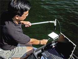
While Han uses digital imagery, provided by the Landsat 7 satellite, scientists with the Gulf Ecology Division of the U.S. Environmental Protection Agency collect water samples in the standard manner, aboard boats using water sampling bottles. With the assistance of handheld global positioning system devices, known as GPS, the researchers aboard the boats know their exact latitude and longitude positions. Those samples are analyzed in the laboratory and then compared to the pixels with the same latitude and longitude locations on the satellite images. In this way, the linkage between the water quality and pixel values on the image can be established.
“I will match, pixel by pixel, with the water sample given to me.”
The 14-person team, known as the Consortium for Estuarine Ecoindicator Research for the Gulf of Mexico, is headed by researchers at the University of Southern Mississippi and includes university representatives from six states. Han is the only scientist from UA.
Through the group’s data collection and computer modeling — designed to predict potential changes in the areas — the scientists hope to develop new indicators of hypoxia. This could assist decision makers in identifying nutrient sources and alternatives for reducing nutrient inputs, as well as examine the costs and benefits associated with reducing the nutrient loads to coastal waters.
The project, slated to continue through November 2005, is funded by a $5.9 million grant from the EPA. Han’s portion of the funding is approximately $200,000. In addition to this project, Han is also assessing the water quality of the Tallapoosa River in east-central Alabama as part of an approximate $550,000 U.S. Department of Agriculture-funded effort. Han is working with researchers at Auburn University and citizen volunteers of Alabama Water Watch in this project, and his share of the funding is approximately $160,000.
Remote sensing is not without its drawbacks, Han said, particularly in analyzing water quality. “Predicting water quality using satellite imaging is a challenge because the water signal is not very strong.” Wave effects, and shallow areas, particularly near the extremely white sand beaches of Pensacola, can also distort the readings. And cloudy days can create havoc in a researcher’s day.
Still, the ability to monitor vast areas of water quickly saves time and money. It’s effective now, and, as the technology continues to advance, will grow more effective.
“Remote sensing technique is something the EPA thinks is a very efficient tool to study water quality,” Han said.
Further Reading