UA developing leading-edge radar system for critical water information
Scientists are always in search of more data to help in understanding the world, and that need drives innovation to gather and analyze the information critical in navigating tomorrow’s challenges.
To grasp the amount of water Mother Nature has poured into a region, scientists have created elaborate models that can show the available water resources and spit out predictions of what’s to come so governments and businesses can plan and position to take advantage. But those models rely on a foundation of data, and the more precise the data, the better people can prepare for, say, a scarcity of water because of dry soil or an abundance of water coming from a thick snow pack in the mountains.
That’s where engineering researchers at The University of Alabama come in. A team of researchers at UA develop, test and deploy radars that can scan and image snow and soil to see the amount of water stored below the visible surface.

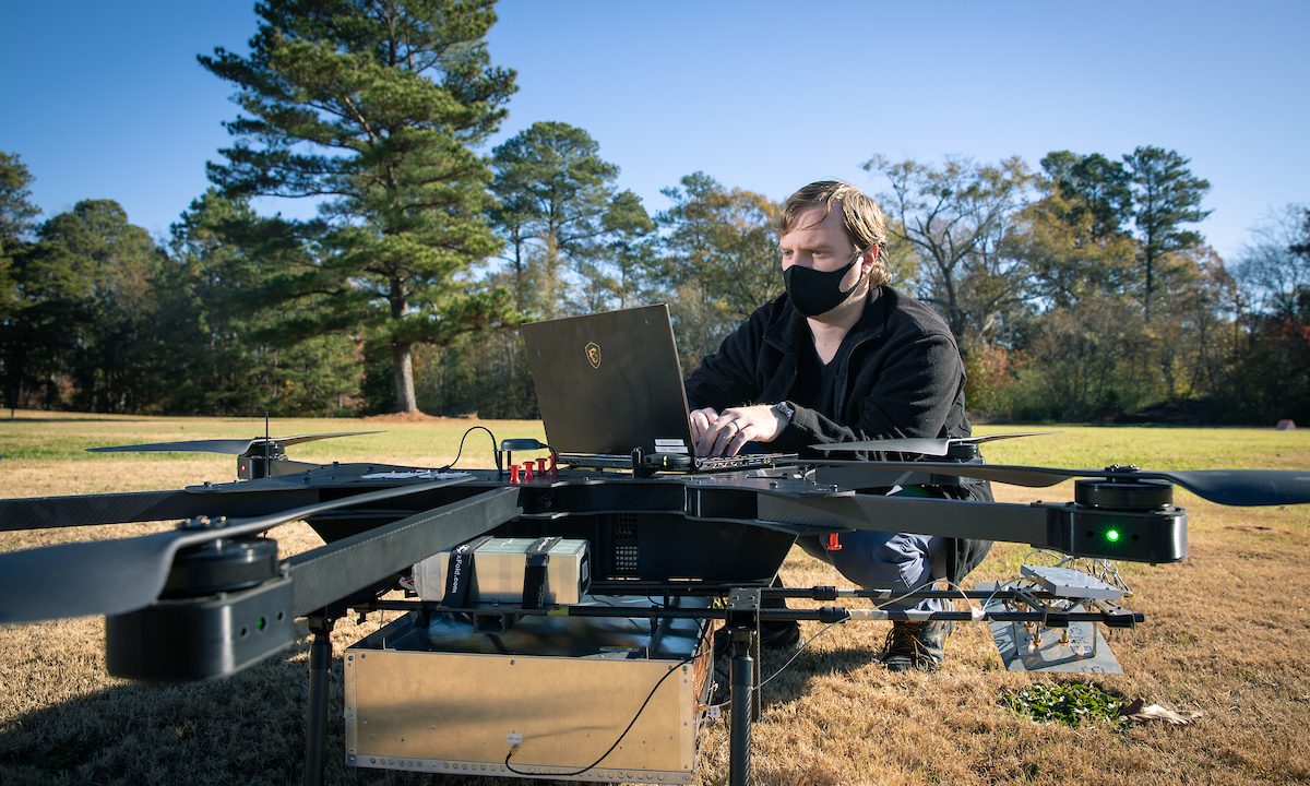
The team at the UA Remote Sensing Center, part of the Alabama Water Institute, have taken radar technology, that used to be mounted on huge planes or trucks and operated by several people, and shrunk them to fit into aerial drones operated from the ground. Leaders in radar imaging, UA researchers are using cutting-edge technology developed at UA to inform decisions on the use of water resources.
“To get fine-scale measurements, we need to get closer to the ground to get a zoomed-in view that satellites and air planes can’t provide, and, in order to do that, we have to fit it on a drone,” said Christopher Simpson, a doctorate student in aerospace engineering who is helping lead the project. “We are miniaturizing the drones, but we can still cover a good bit of land with this system.”
The information collected and analyzed by the UA researchers will feed into hydrological models such as the National Water Model maintained by the National Oceanic and Atmospheric Administration through the National Water Center, located in Tuscaloosa, Alabama.
“The application is water management,” said Dr. Stephen Yan, who specializes in radar and antenna systems research. “What can be done with the data depends on the user, but in uploading this data on snow volume and soil moisture to the broader community, we help develop and validate models that can be used to see if there might be a flood or drought to help planning with drinking water or water for crops.”
While satellite imaging covers huge areas of land and on-site measurements of geophysical data provide detailed information at specific locations, neither provide the fine imaging resolution over a large enough area for the accuracy desired in hydrological models.
“With any model, the finer the resolutions you can capture, the more accurate you can be,” Simpson said. “The fine-scale measurements give you more fidelity in certain situations.”
“To get fine-scale measurements, we need to get closer to the ground to get a zoomed-in view that satellites and air planes can’t provide, and, in order to do that, we have to fit it on a drone.”
Satellite imaging and radar mounted on airplanes scan the Earth with resolutions on the kilometer scale, meaning those images can only provide an accuracy of what’s under the surface within 30 kilometers, for instance. That’s great information for models, but a clearer picture can be captured using UA-developed radars mounted on drones that can provide a resolution close to 10-meter scales.
The ultra-wideband radar operating at microwave frequencies is able to see below the surface at low altitudes. The drone-based soil moisture radar also has sufficient sensitivity and resolution to see through trees and vegetation, isolating their effects from soil moisture measurements – a capability that was not possible from existing drone-based radars. Four drones with integrated radar, a set up weighing about 55 pounds, working together in an automated pattern can do a broad sweep of an area in a short period of time.

Dr. Jordan Larson, who researches unmanned aerial vehicles, and his students are helping the team by developing drones on campus tailor-made for this imaging project. The goal is to move to a swarm operation to minimize downtime in charging drones between flights by covering even more land.
“If you want to be efficient, you want to cover as much space as you can with as many drones as you can that fly for longer periods of time capable of a fine resolution,” Larson said. “There is no other leader in this area, so it’s easier to design this ourselves.”
The team also uses in-situ measurements to help give the drones a baseline that helps validate radar estimates of soil moisture during processing. Sama Memari, a graduate student in civil and environmental engineering, uses probes that stick 5 centimeters in the ground to measure soil moisture and inputs vegetation coverage of the area.
“We need to have some ground truth to calibrate and verify the data,” Yan said.
All of this data will help in modeling the future state of water in a region.
“Hydrologists can use this information to determine the state of the soil in different seasons, and our goal is to provide more accurate data for those water management needs,” Yan said.
This work is supported through NOAA by a $5.5M grant through the Cooperative Institute for Satellite and Earth System Studies at the University of Maryland.
Dr. Yan is an assistant professor of electrical and computer engineering and deputy director of the Remote Sensing Center. Dr. Larson is an assistant professor of aerospace engineering and mechanics. The Remote Sensing Center is led by Dr. Prasad Gogineni, the Cudworth Professor of Engineering.
Contact
Adam Jones, UA communications, 205-348-4328, adam.jones@ua.edu