
Technology for the sake of technology is fairly useless.
But, when it can be used to help solve problems or open the door to unanswered questions, the possibilities are endless.
“People are always coming up with new questions, and every time you come up with a new question, you have to find a way to answer it,” says Matt Gage, director of The University of Alabama’s Office of Archaeological Research. “But, getting to that answer may require coming up with a whole new way of looking at something.”
From 3D imaging and printing to ground penetrating radar and photogrammetry, UA archaeologists and researchers have recognized the importance of using these tools of the future to better understand the past.
3D Imaging
Archaeological excavation, by its very nature, results in the destruction of an archaeological site. But, by meticulous documentation and artifact recovery, “what we’re able to do with this 3D work is recreate in virtual reality what’s being destroyed in reality,” says Jeremiah Stager, cultural resources assistant at OAR.
They do this in two ways: 3D modeling and 3D documentation.

With 3D modeling, researchers use historic photos and maps to rebuild something that no longer exists. Stager was able to use fire insurance maps, some sketch drawings from a historic architect and a few rare photographs from the late 19th century to virtually rebuild a downtown Tuscaloosa city block where the Embassy Suites Hotel now stands, including the location of the Bank of the State, the Drish Building on the corner, a tavern and one of the first log buildings in the city.
A more recent example of 3D modeling is the Lay Dam project. Construction of the dam (it began operation in 1914 and is one of the oldest hydroelectric dams in the country) spawned a village. The village – once the temporary home of construction workers and their families – later transformed into permanent housing. Of the nearly three dozen buildings that once existed in the village, only two remain, Stager says.
Using planning maps from the Alabama Power archives and hundreds of historic photos from families who lived and worked there, Stager virtually rebuilt almost the entire village, which can be viewed in a video tour.
“It brings archaeology, history and a little bit of anthropology together,” he says. “3D modeling really connects well with people, especially kids. When I’m excavating at a park and a group of visitors comes up to me, and I’m trying to show them the dirt stains, which we think are really interesting, sometimes it’s hard for people to envision what was there. With 3D modeling, I’m trying to tell a story, help them re-imagine what it was like.”

Stager also utilizes 3D documentation, a method in which he takes multiple images of something that still exists, whether it’s an artifact or historic building, and creates a replica. This method makes the images easier to share across the Internet. Rather than someone traveling to Moundville to see an artifact, Stager can create a 3D model, upload it to a website and share the image with a virtual visitor. They can rotate it, look inside and even take measurements – all online, he says.
The next step is the 3D printing of artifacts. OAR works with UA’s 3D Printing Lab to generate replicas that, while not exact, are useful for display and handling by visiting school groups.
“Sometimes artifacts break,” Stager says. “It would be good to get a good scan and then print them while they are still whole. It would also provide a better experience for museum visitors.
“While having the ‘real’ artifact behind a case looks cool, and it’s really neat to look at or read about, being able to interact with it often gives people a much better experience. It is a huge tool in connecting with the public.”
Remote Sensing
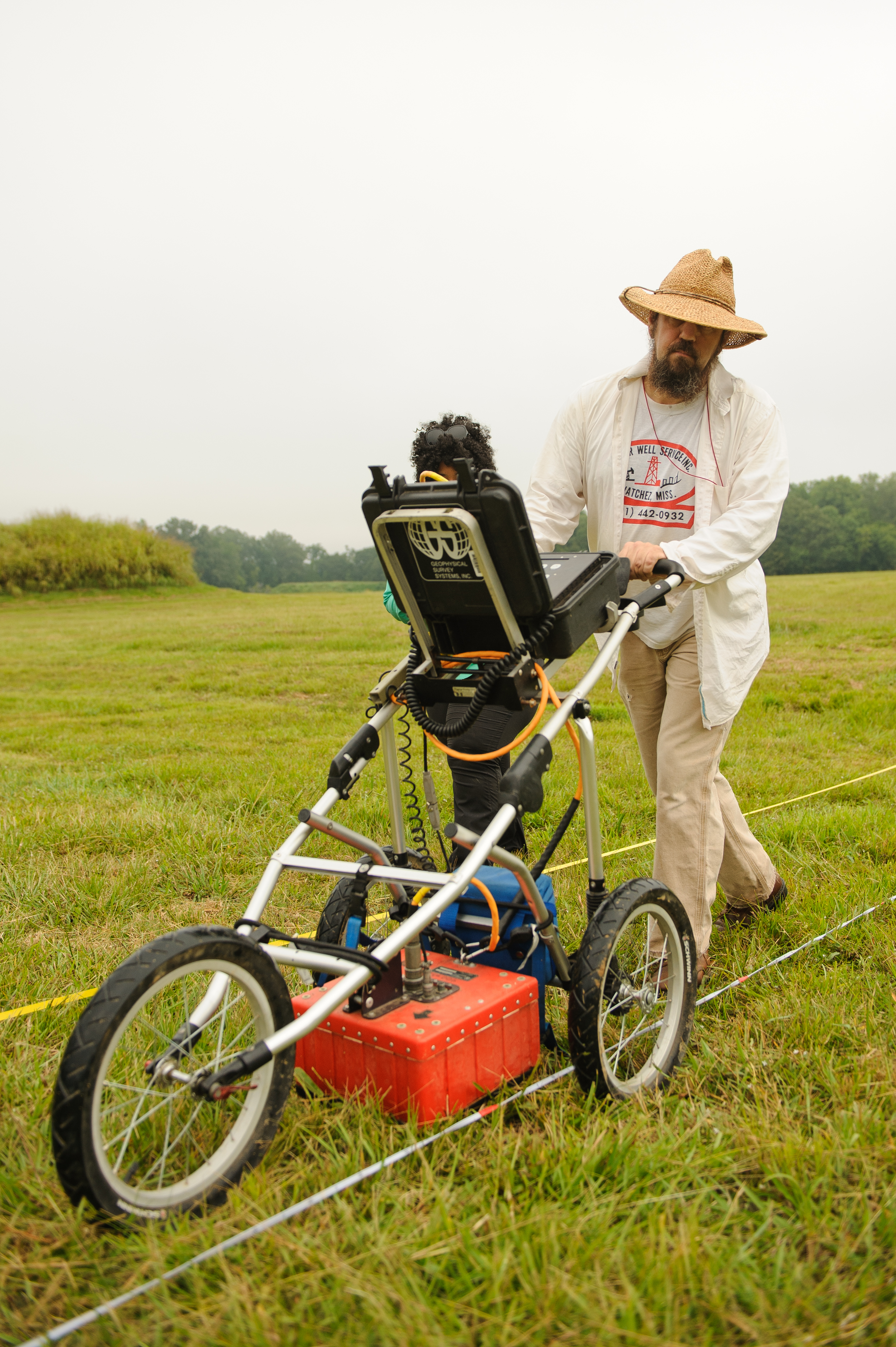
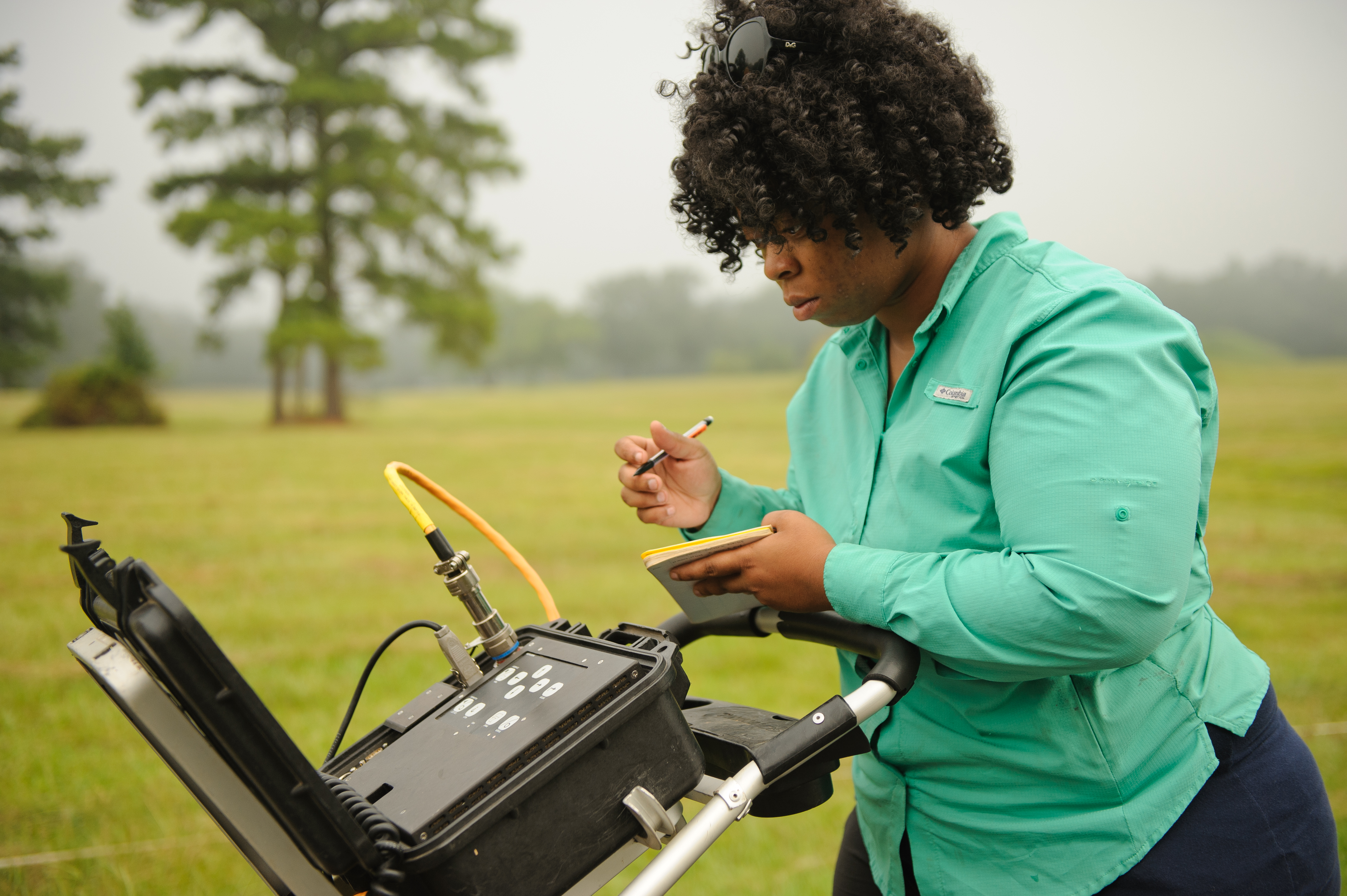
Remote sensing technology has been around for decades, but some of its uses have evolved over the years. For instance, ground penetrating radar was originally used to identify tunnels in Vietnam, but UA’s Office of Archaeological Research utilizes it to identify graves, prehistoric fire hearths, storage pits, post holes and more.
“We use it to identify subsurface anomalies that are anthropogenic in origin,” Gage says. “It allows us to investigate under the surface without actually doing excavation.”
OAR uses ground penetrating radar primarily for mapping cemeteries, which has proven particularly helpful with older plots that have numerous unmarked graves.
Gradiometry is another tool regularly employed by OAR. This technology is used for near surface features and produces a higher resolution picture, which allows archaeologists to see smaller items.
Through the use of gradiometry, the UA researchers have discovered single-set post holes indicating a home’s outline, as well as fire hearths, disposal pits and borrow pits – where people mixed clay to make pottery or made daub to smear on the outside of houses.
Dendrochronology
Oftentimes, OAR staff not only pulls in technology while searching for answers to the past, they also employ other science methods, such as dendrochronology, which is the study of tree rings.
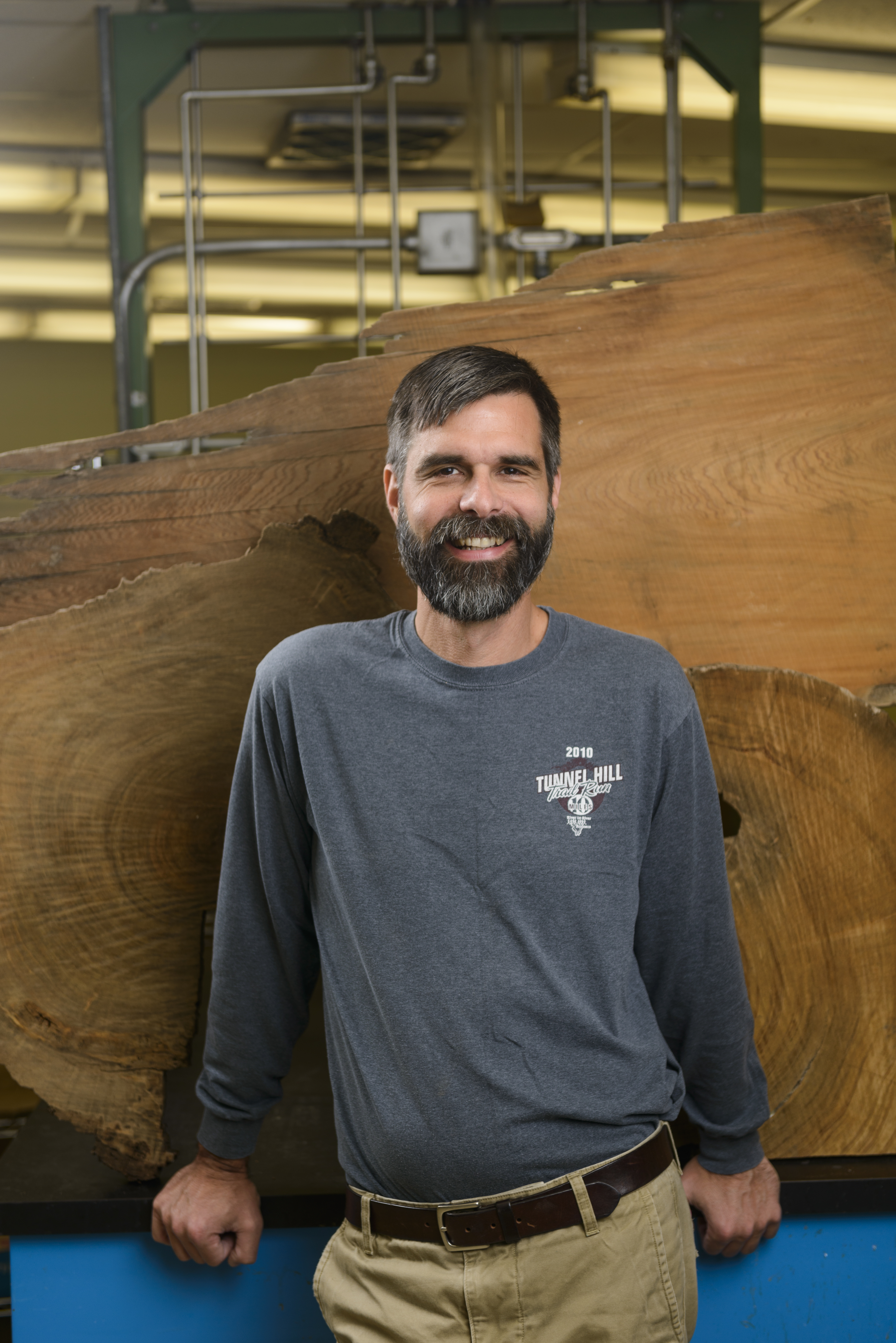
Tree rings are the most accurate form of geochronology, says Dr. Matthew Therrell, an associate professor in UA’s geography department. The formation of each ring can be dated, so dendrochronologists know exactly which year the ring formed. This can be used to determine when a tree was cut down.
This method is helpful to OAR when a project involves dating wooden structures.
“There’s no real way to tell when a building was built unless someone wrote down when they cut the trees and started building, but no one did that,” Therrell says. “Sometimes researchers will look at tax rolls to see when a property became more valuable and then make the assumption that is when a structure was added on the property. But, you still don’t know for sure.”
Dendrochronology, however, can not only reveal which year the trees were cut, but also the season, which is a good indication of when the structure was built. OAR most recently utilized this method in determining the age of three separate cabins and whether those cabins were built in association with the Creek Indian War.
The speculation was that the cabins had been part of Fort Armstrong, which was built on the banks of the Coosa River and then later incorporated into Snow Hill Plantation, Gage says. In actuality, the logs were cut in 1849 and 1855, which means they were definitely not part of Fort Armstrong, he says.
In addition to the historic significance, these wooden structures also have a lot of scientific value, Therrell says. In the Eastern United States, it is difficult to find trees more than a couple hundred years old.
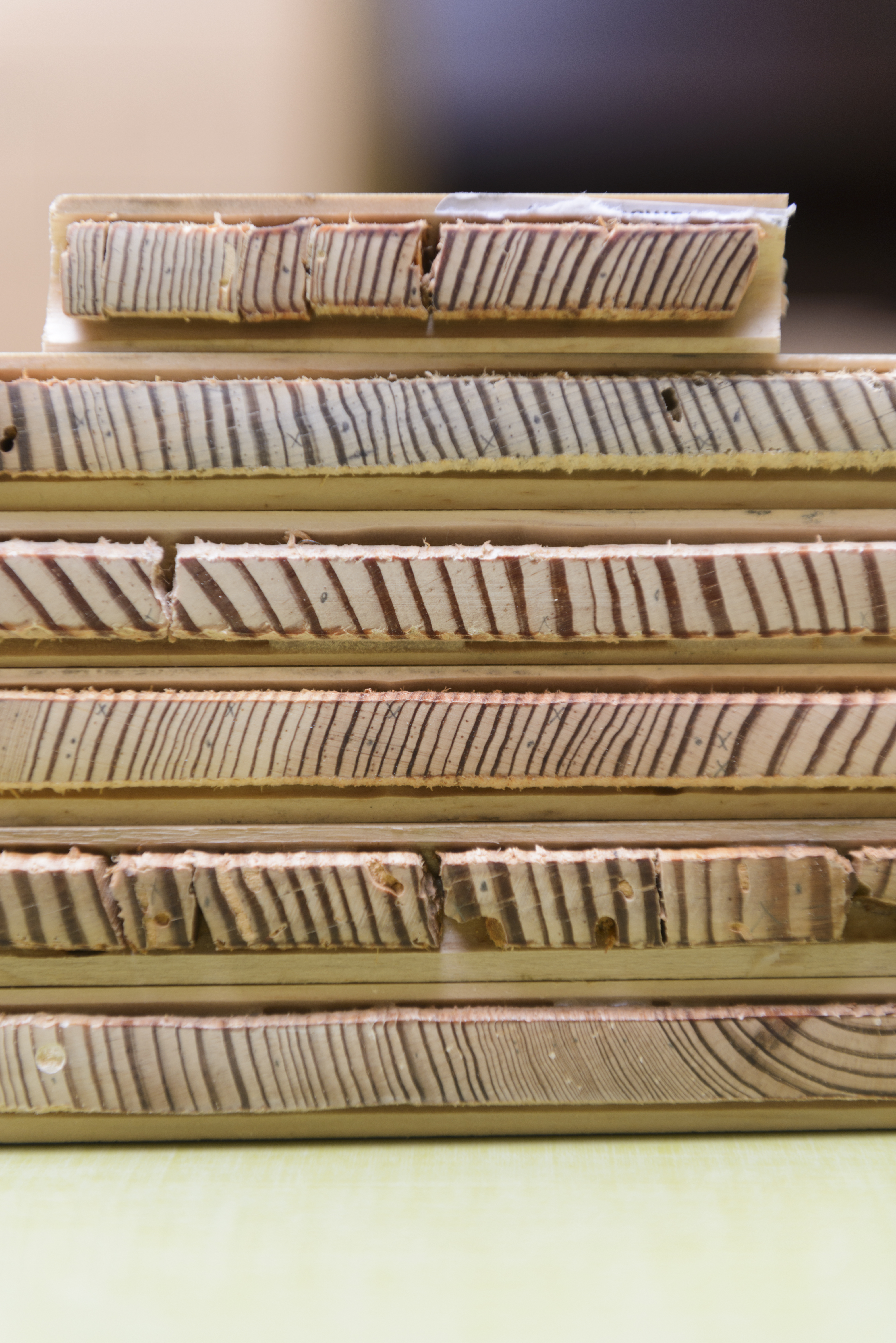
“The great thing about wooden buildings is that the trees were cut down when they were probably about 150 years,” Therrell said. “It allows us to extend our chronology further back into the past than if we were to study living trees. We’re getting geophysical data that we would not get otherwise – helping us in understanding climate change. It’s a record that’s been preserved.”
The Future of OAR
As technology develops, OAR will strive to use those tools to help uncover even more answers to lingering questions.
“It boils down to efficiency and cost reduction,” Gage says. “Everyone wants to get the most information for the cheapest amount of money. A lot of this technology allows us to interpret large areas and be able to examine things that we wouldn’t normally be able to see in a fast, noninvasive way.”
OAR has worked with multiple colleges and departments across UA’s campus in creating tools that will help further its research.
“It’s great for us to be able to experiment and create things that will work for what we need,” he says. “We can look at what other researchers have done and what has worked and not worked for them, and then make our own.”
Employing technology to help find answers, however, is not the same as using technology to do the labor.
“We are the ones that ask the questions,” Gage says. “We’re the ones that have to find the answers. You can use technology to identify a shape or color or pattern, but someone still needs to ask the question in the first place.”